Below is in extract from Lincolnshire County Council website.
We are responsible for the mapping, management and enforcement of public rights of way and work with farmers and other landowners to ensure access is not affected.
Rights of way are classified according to the nature of their use:
- Footpath – foot only
- Bridleway – foot, cycle or horseback
- Restricted Byway – foot, cycle, horseback or carriage
- Byway Open to All Traffic (BOAT) – foot, cycle, horseback or motor vehicle
A ‘permissive path’ is where the landowner allows the public access but may close the path occasionally.
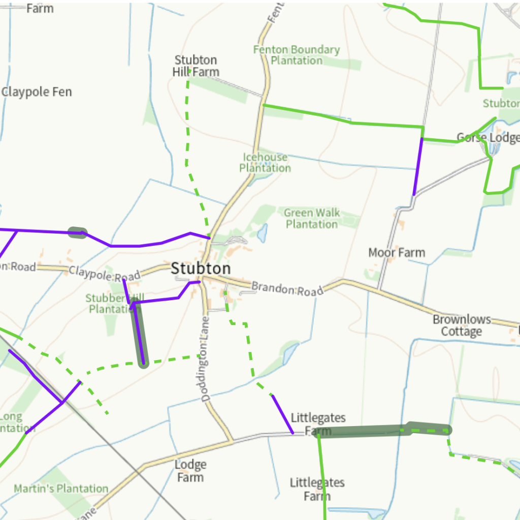
Public rights of way are recorded on Definitive Maps. The original copies of these maps can be viewed by appointment at County Offices and remain the legal document for Public Rights of Way in Lincolnshire.
The Electronic Working Copy map shows public rights of way as they are recorded today following any additions, diversions or extinguishments. This should not be considered to be the legal document.
Rights of way can only be closed with our permission. The Temporary Closures register records planned closures where a right of way will be affected by works.
Livestock can be kept in fields crossed by rights of way. The exception is bulls on their own if over 10 months old. Beef bulls are allowed if kept with cows, however, dairy breed bulls are not.
Farmers, landowners, and the county council work together to maintain and manage rights of way.
Whilst in the countryside please act responsibly and follow the Countryside Code.
The electronic working copy is a representation of the original Definitive Map with all subsequent alterations taken into account.
It should be noted that this map is NOT the Definitive Map (legal record) and, that whilst every effort to attain accuracy in translation from the original paper mapping has been made, no liability is accepted for any errors particularly when viewed at scales greater than the original mapping.
We apply a working presumption that routes on the list of streets have public vehicular rights. Legislation has extinguished the rights of motorists if these are also shown as a:
- public footpath
- public bridleway
- restricted byway
You can zoom to a location on the map, or search for an address however rights of way on the electronic working copy map will only be displayed between 1:2,500 and 1:250,000.
Individual path numbers can be found by selecting the individual right of way using your left mouse button.
For licensing reasons we are no longer able to provide information on permissive paths and other areas of countryside access in the way we used to.
Link to MAP.